
South China Sea Strategic Assessment
The FORCES South China Sea (SCS) project aims to empirically test theory-driven strategic scenarios that might lead to conflict in the maritime area of the SCS. We implement a flashpoint analysis that focuses on sites most likely to spark conflict. A recently published article in National Interest reveals that the flashpoints are aligned with the "first island chain," which pushes the South China Sea toward the edges of the Western Pacific.
The flashpoint model results from spatial analysis of territorial claims and counter-claims in the South China Sea region. The model is designed to highlight the most significant areas of potential conflict at present and in the future. By creating an overlapping hierarchy of flashpoints, the model provides information on potential issues in the current liberal world order that is heavily concerned with the conduct and actions of China. The model offers a descriptive data analysis of the People's Republic of China's (PRC) desires and geospatial analysis of valuable assets under economic, lawful, and military influence.
Our analysis includes Taiwan, China, the Philippines, Japan, Malaysia, Indonesia, Brunei, Vietnam, North Korea, and South Korea. Many of the nations in our study hold varying geopolitical concerns with differing limits of influence in the region.
While the span of our analysis continues to grow, we find that the Malacca Strait, Taiwan, and the Philippines are currently the areas of most significant concern for future conflict. We look forward to increasing the validity of our research agenda with multiple government and non-government agencies. The lead analyst is the FORCES Junior Fellow Matt Ellis, a doctoral student in the Political Science Program at Purdue University, working with Dr. Sorin Adam Matei, Ph.D., the FORCES director.
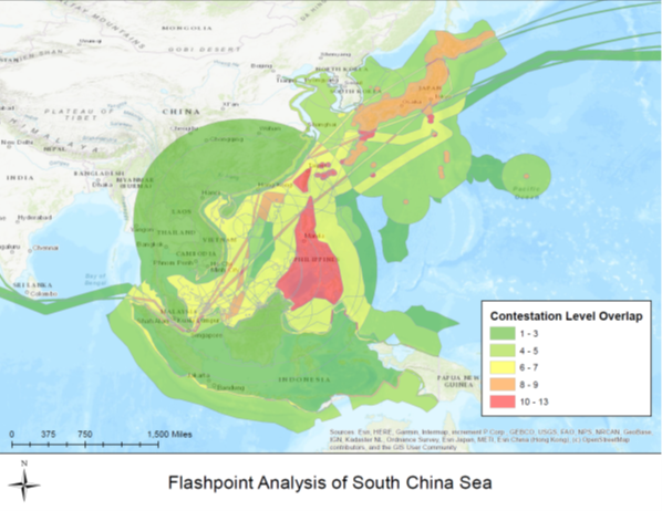
Map generated by flashpoint analysis performed by the FORCES initiative at Purdue University.
The red spots and areas were created by projecting the Chinese strategic ambitions induced by vast sea claims and militarization of the seas over local and global claims, resources, and commons, such as sea lanes or fishing grounds. Statistically, we obtained the red flashpoints by valuing and overlapping the territorial claims (accepted and unaccepted by international law), military power projection potential (missile or aircraft ranges), the topography of the shipping and telecommunication lanes, and the natural resource claim areas. The layers were rank-valued. The highest were the ones that reflected the most valuable assets (immediate coastal regions), while the lowest were the ones least likely to be contested, such as shipping lanes.
An interactive version of the map can be found at https://arcg.is/1Le4yj . A copy of the methodology can be obtained by request from the authors.